Are you looking for a home or condo near a metro station? Use our site to find properties close to Metro stations.
For more information or to set up an appointment call Julie at (703)765-0300.
By Nesbitt Realty – a family business
Are you looking for a home or condo near a metro station? Use our site to find properties close to Metro stations.
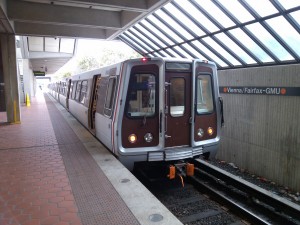
 "Transit-oriented development" sounds like a solution to a variety of urban problems. If people could live and work within walking distance of a train or bus stop, people could save money on gas, people without cars could commute more easily, neighborhoods could reduce congestion and pollution, and economic growth could follow.
Generally, it makes sense for cities to invest in the hubs that connect people and the places they need to go. However, not every rail stop is equally primed for a new apartment complex or retail development, and determining why is a significant challenge. For example, there is little sense in pushing transit-oriented development in a community where every household already has multiple cars, and likewise there is little sense in developing stops in areas divided by highways and mega blocks where people are unlikely to walk to a train.
In early February, the Center for Transit-Oriented Development released a study of more than 100 transit stops in the Pittsburgh area, assessing the suitability for transit-oriented development. A quarter to half of the station areas in the system could benefit from a small infrastructure investment, such as a pedestrian bridge or tunnel, signage showing where the station is, or paved pathways or sidewalks. The assessment uses pentagonal graphs to illustrate ways that density, land use, care dependency and distance all shape communities differently.
"It’s a very simplistic way of measuring what you need," says CTOD director Abigail Thorne-Lyman. "But if you don’t have the resources to even know where to begin, it’s very powerful to say ‘I’m just going to look at these five things, and what do I need to improve to push myself into a more transit-oriented urban form?'"
Source: "The Geometry of Transit-Friendly Neighborhoods," The Atlantic Cities (02/11/13)
"Transit-oriented development" sounds like a solution to a variety of urban problems. If people could live and work within walking distance of a train or bus stop, people could save money on gas, people without cars could commute more easily, neighborhoods could reduce congestion and pollution, and economic growth could follow.
Generally, it makes sense for cities to invest in the hubs that connect people and the places they need to go. However, not every rail stop is equally primed for a new apartment complex or retail development, and determining why is a significant challenge. For example, there is little sense in pushing transit-oriented development in a community where every household already has multiple cars, and likewise there is little sense in developing stops in areas divided by highways and mega blocks where people are unlikely to walk to a train.
In early February, the Center for Transit-Oriented Development released a study of more than 100 transit stops in the Pittsburgh area, assessing the suitability for transit-oriented development. A quarter to half of the station areas in the system could benefit from a small infrastructure investment, such as a pedestrian bridge or tunnel, signage showing where the station is, or paved pathways or sidewalks. The assessment uses pentagonal graphs to illustrate ways that density, land use, care dependency and distance all shape communities differently.
"It’s a very simplistic way of measuring what you need," says CTOD director Abigail Thorne-Lyman. "But if you don’t have the resources to even know where to begin, it’s very powerful to say ‘I’m just going to look at these five things, and what do I need to improve to push myself into a more transit-oriented urban form?'"
Source: "The Geometry of Transit-Friendly Neighborhoods," The Atlantic Cities (02/11/13)